If you think you’ve already seen every crater on Lanzarote, you’re wrong! We bring you our personal hiking guide to Volcán de la Corona (605 m), one of the oldest volcanoes on the island. Find out how to avoid conflicts with local farmers, what adrenaline rushes Monte Corona offers, and what the difference is between Mirador del Río and Mirador de Guinate. As a bonus, we have a tip for the authentic local pub Casa Rayco in Máguez and the best Paella in Arrieta. Get ready for the wildest trails in the Parque natural archipiélago Chinijo!
Mirador del Río: Manrique’s Nest and the El Río Strait (View of La Graciosa)


Arrive, queue up, climb onto the terrace, peek, snap some photos, grab a quick coffee, and leave. Then, you might climb over the fence to get to the artillery bunker, where you can see the Mirador del Río terrace itself laid out before you. If you want the full experience inside, you’ll pay a few euros entrance fee.
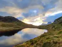
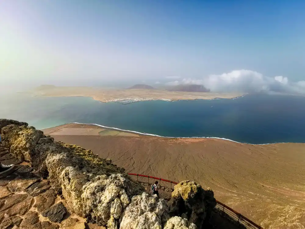
Mirador del Río sits 400 meters above sea level and is also linked to the name of César Manrique. The restaurant and terrace were created next to the remains of an old military battery from the late 19th century. From the terrace, you’ll get a wide-open view of El Río—the narrow strip of sea separating Lanzarote from the island of La Graciosa.
Our Personal Tip: How to Discover Mirador del Río for Free and Bypass the Entrance Fee
If you scout around a bit, you’ll find a path leading around to the battery bunker, which is located several meters higher than the viewpoint itself. But don’t linger too long. Just 2 km further, in the village of Ye, you’ll find the hiking trail to the Monte Corona crater, which will impress you even more.
🌋 Volcán de la Corona: The Ascent, Crater, and Heart of Parque natural Chinijo


At 605 meters, Volcán de la Corona is one of the highest volcanoes on Lanzarote. It is much older than Timanfaya, and from its peak, you look down significantly on Mirador del Río. The volcano erupted 5,000 years ago, and together with its four neighbors—La Quemada de Maguez, Los Helechos, La Cerca, and La Quemada de Orzola—it uplifted the island to its present form. The Monte Corona crater offers one of the most adrenaline-pumping experiences on the island.
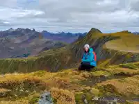
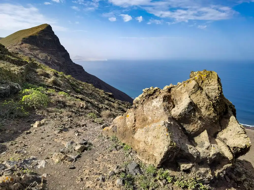
Monte Corona with a View of Mirador del Río
Its formation created the island’s second natural park: Parque natural archipiélago Chinijo, which includes the island of La Graciosa.
If you follow the map, you’ll end up arguing with a local aloe-vera farmer. Part of the marked route led (or used to lead) through his fields. The farmer, not one to waste time, blocked the path with rocks. We tried to open our Slovak hearts to him. It was impossible. To our polite inquiry about where the marked path actually leads, he started rambling about police and was swaying slightly. The wise one steps back. We took the route from a different direction.
About a one-kilometer path led us through fields to the base of the mountain. There, the path dramatically steepened, and we ascended 250 meters over the next kilometer. When I reached the edge of the crater, I was stunned, watching the view without taking photos for a while.
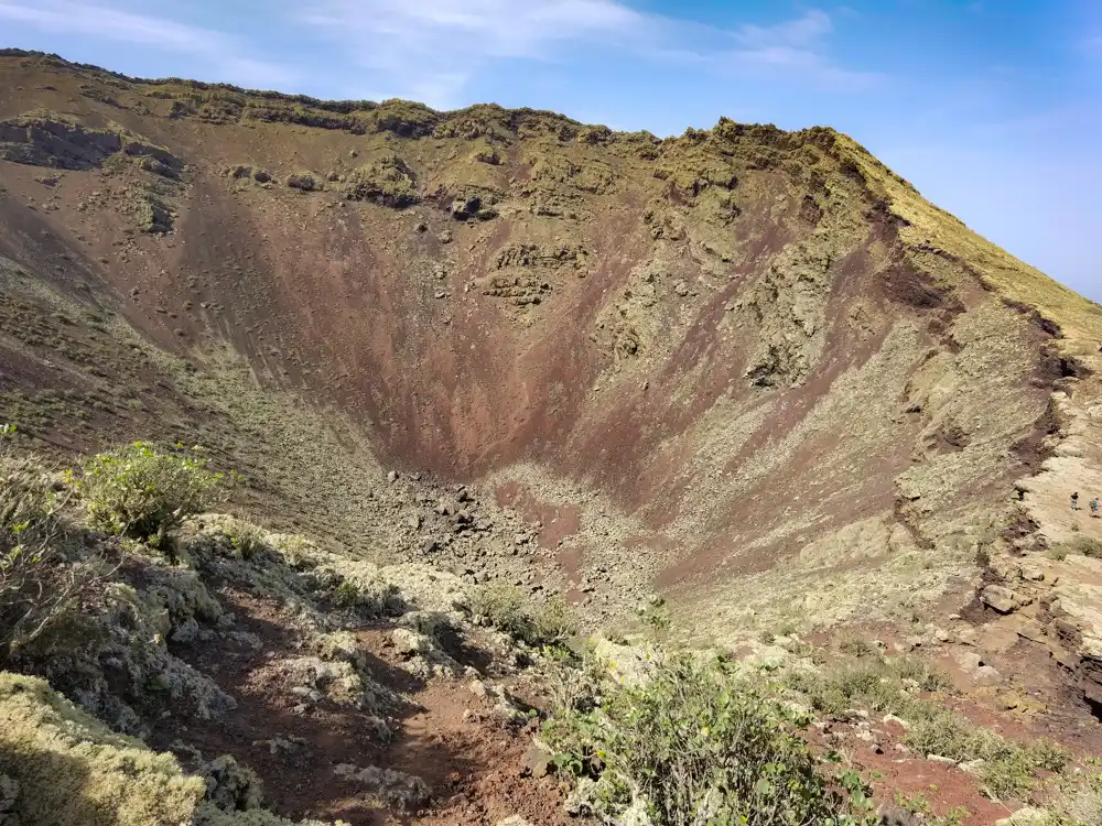
Adrenaline Crater: 250m Deep and Respect on the Edge (Our Feelings)
The volcano looks different from the others on the island—given its diameter, it is much deeper. It’s not as large as Caldera Blanca, but it feels significantly more adrenaline-fueled. Although we saw a few people on the horizon, we didn’t dare attempt a full circuit around the entire crater.
The NP Archipiélago Chinijo, covering 700 km², is the largest marine reserve in Europe. Besides the islands of La Graciosa, it also includes the half-kilometer-high Risco de Famara cliffs, which were created by the lava eruptions from these very volcanoes 16 million years ago.
Malvasia and Wineries: Cutting Across the Vineyards (Our Personal Tip)


We turn and continue along the path of forgotten volcanoes. We shortened our route by cutting through a local winery, and after paying for the damage we caused to the farmer’s inventory in the form of a bottle of Malvasia, he warmed up to us and let us walk straight through his vineyards. Even though they usually don’t like it.
Mirador de Guinate: An Even Better View of La Graciosa?
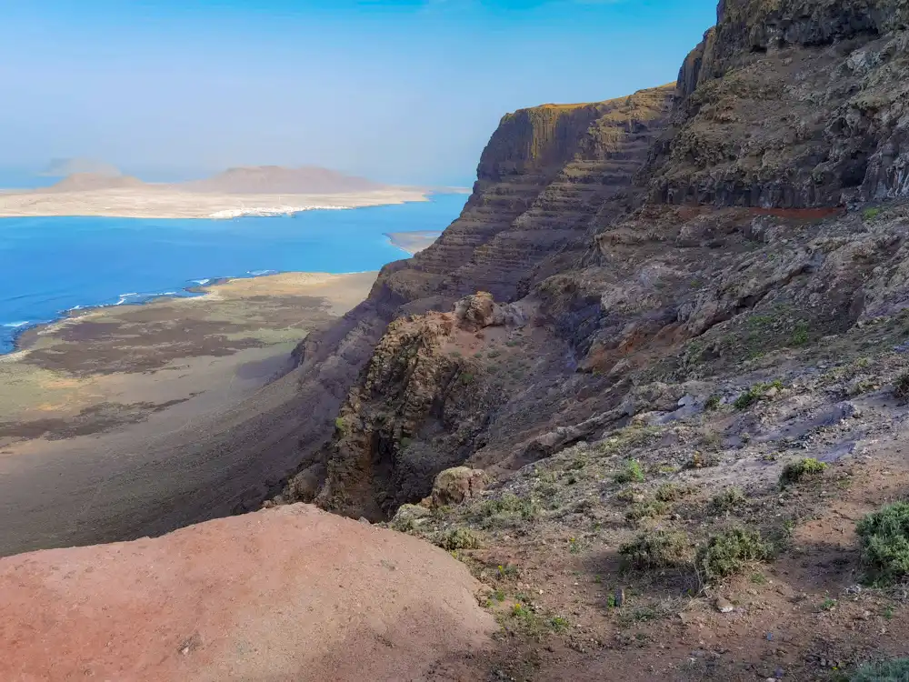
I don’t know if you can find a more beautiful view from these cliffs. The entire Risco de Famara cliff range stretches from Mirador del Río through Máguez, Haría, right up to the boundary of Teguise.
Don’t give up. Every journey begins with the first step.
— The wisdom of a brave long-distance hiker
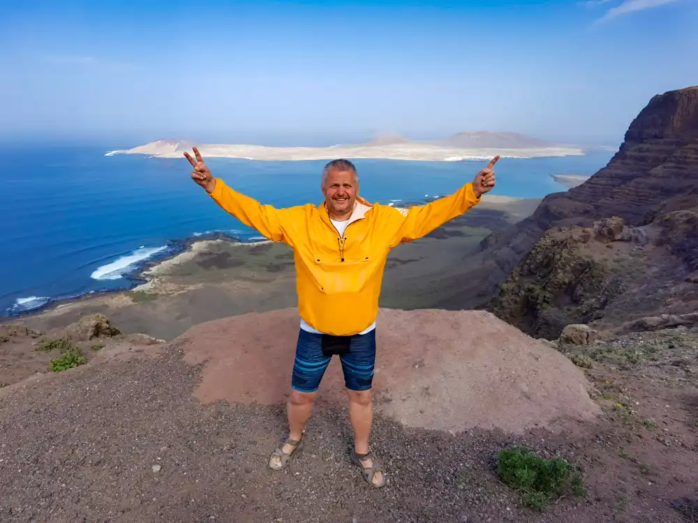
First, we hesitated whether the detour was worth it. Then, we had no regrets. Perhaps it is from these cliffs that you will discover even more beautiful views of La Graciosa than from Del Río itself. And that’s exactly what happened.
The most beautiful spots are discovered when you take the unmarked trails. Although a farmer’s fence crossed our path several times, we didn’t give up.
Practical Tip for Hikers: Sandals with Vibram vs. Sturdy Boots 🥾
Long walking trails on Lanzarote taught me that you don’t always need closed, sturdy footwear. With great enthusiasm, on the second day, I invested in sandals with a Vibram sole and started walking in them. They are perhaps not for treacherous paths and lava fields. But for regular long-distance hikes, my feet truly appreciated the freedom and ventilation. My partner, Milan, appreciated it too—whenever I took them off in the evening.
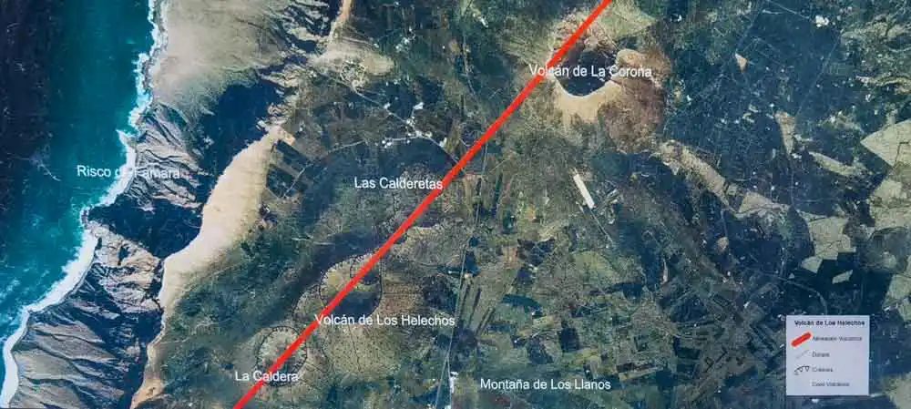
Trail Around Camino de Gayo: Past Volcanes Los Helechos and La Caldereta
The Camino de Gayo trail led us past the Volcán de Los Helechos to the village of Máguez below Haría.
The Canary Islands are supposed to be about relaxation. About the sea, sun loungers, and animators, all-inclusive meatballs, noodles, powdered juices, unlimited consumption of local spirits, and guided sightseeing tours by bus. But where do you categorize the crazy people who meet only five other people all day long?


Descent into La Caldereta
I’ve been on a volcano and at the edge of a crater, but never inside one. I fixed that with a descent into La Caldereta. I also wanted a Selfie. Photo up. Can you find me in La Caldereta? Just for scale. 🙂
The reward in the village of Máguez was enormous.
Drink in Máguez
All tourist spots pale in comparison to the sleepy Casa Rayco, where Caribbean music and Buena Vista Social Club play. A pub so authentic it hurts. It mostly hosted locals who burst into laughter at every lost tourist-driver. This was because the road to Haría was being repaired, and the roundabout detour via dirt roads led right past here.


We soaked up the pulse of this sleepy village like no other place on Lanzarote.
Arrieta Beach: Surfer’s Paradise and the Best Paella on the Island (Our Gourmet Tip)
We ended the day on the beaches of Arrieta. Not because we needed to soak our feet. Not even because it’s a surfer’s paradise. Rather, because for €7.50, we got the best Paella with fresh seafood on the island right here. 🙂
Lanzarote: Today, based on our personal experiences and recommendations, we completed a hike across four craters for Lanzarote’s most beautiful views. Really? Because tomorrow, we face the hiking peak in the form of a ridge-top cliff crossing between Haría and the medieval town of Teguise, the former center of Lanzarote.


⚠️ Important Warnings for Volcán de la Corona (Based on Our Personal Experience)
- Sturdy Footwear: ⚠️ Despite your sandal experiment, for the ascent into the Monte Corona crater and crossing the lava field, we recommend sturdy, closed footwear for safety and climbing.
- The Route: 🗺️ Be prepared that officially marked routes may be barricaded (farmland). Download a map and be ready to find a detour.
- Water: The route is moderately long (approx. 8-10 km loop if you don’t get lost), and there are no refreshments along the way. 💧 Water and sun protection are essential.
- Parking: 🚙 Park in the village of Ye (or on the edge of Máguez) and find the correct trailhead to avoid unnecessary walking on asphalt.
- A quick tip for discovering volcanoes Los Helechos and La Caldereta: 🚗 Don’t be alarmed by the drive up there by car. It’s not as bad as it looks. You can park and turn around at the end.